|
||||||||||||||
MINOR RESEARCH PROJECT
Title
Archaeological Sites Along
with Distributaries of The Ganges in
Begusarai District
Executive
Summary
of
The Final Report
Submitted
To
The Joint Secretary and Head
Eastern Regional Office
University Grant Commission
L.B.-8, sector-3
Salt Lake
Kolkata - 700098
During XIth Plan Period
2011-13
By
Principal Investigator
Dr. Shailesh Kumar Sinha
Head, Associate Professor
Department of Ancient Indian
History, Culture& Archaeology G.D.College, Begusarai – 851101
Bihar
PRINCIPAL INVESTIGATOR
DR.
SHAILESH KR. SINHA
CO- INVESTIGATOR
DR.
AMIYA KRISHNA
Executive Summary
Begusarai district is one of the
thirty-eight districts of Bihar and Begusarai town is the administrative
headquarters of this district. The district lies on the northern bank of the Ganges
river. It is located at latitudes 25015’N & 25045’N
and longitudes 85045’E & 860 36’E .
Here, in this project, we
have tried to locate the distributaries of the Ganges which had marked its
imprints in this region somewhere in the past. Though, these distributaries
have lost their existence due to several reasons, their contribution to the
regional culture is intact in the form of archaeological remains buried under
numerous mounds along with them.
The Ganges has always
attracted many tributaries and given shape to a number of distributaries. It’s
catchments area also has changed the shape and direction from time to time. The
old bed of Baya, Deoki etc. have many ancient sites on its course and these
distributaries managed to find their way up to the famous ‘chaur’ area of the
region nourishing many sites in the past. The remains of a water channel right
from Bachhawara and Teghra to Kola Chaur via Asurari, Chanan, Jhajhpur and
Chandpura can be seen. The Bainti, Balan and Burhi Gandak have given birth to
sites like Naulagarh, Birpur, Baraipura etc.
The Kola Chaur nourishes the
sites of Masuriya dih, Damdama, Sughran, Kushmahot, Chamrahadih etc. Many rich
archaeological sites like Kumharso, Herson, Garhi, Garhpura etc can be seen in
the Chanha region. The famous Kabar lake is surrounded by Jaimangalgarh,
Garhkholi , Ekamba and many other sites of this area.
Even
the recent catchment area of river Ganges has many historical sites like
Shograha Dih, Bihat, Matihani, Maniappa, Majhalapur, Balia etc.
The
Kola Chaur is a vast area of almost 10 kms. East-West and 9 kms North-South expansion. The topology is
remarkable. The slope is towards East. The old bed of Devaki (deoki) river is
alive here with a channel (almost dried normally) from the north of
Maharathpur, Fatehpur, Laruara, Sikandarpur and Sankh. The river bed is
apparent and contains water for not less than half a year near Sankh,
Taraiya, Tulsipur and Kaith-Baraith. This river bed can be seen along with the
Sankh-Jinedpur road. At Damdama, Sangokothi and Cheriyadih,the water confluence
of the region is still alive and can be seen in the rainy seasons. Cheriyadih
becomes the junction of this water confluence from where a stream runs towards
south and the other towards north. The main river bed of Budhi Gandak at
Chanpura lies only two or three kms. north to this live old channel. The
topology suggests that the old channel might be supported by the oversaid river
in the past. There are a number of archaeological sites all around this chaur
area. To its west lies Sankh, Rajaura- Sikandarpur etc.; to its north Kaith,
Baraith; to its east Kusmahaut, Bodidih, Majhanpur, Chamrahadih, Sugharan etc.
; to its south Kankaul, Suza ; Masuriyadih, Manikpur, Sangokothi, Damdama and Cheriyadih lie in the central
part of this chaur.
We
have talked about Devki earlier. This distributaries would have emerged with
some northward change in the direction of the main course of the Ganges
somewhere near Barh in Patna district on the southern flank. Though it has lost
its existence as a live stream its marks can be seen in the form of dead
river-bed. Not less than six dead channels of this lost distributaries are
visible in the rainy season.
The
imprints of the first dead channel can be seen at Teghara , Barauni and western part of Kola chaur. This
could be the oldest and the largest current collecting the rainy-day water
run-off and pouring it to the Budhi Gandak. This particular stream seems to be
emerging somewhere in the Chamtha diyara and rushing through Vajitpur Bajar
flows in the diyara of Bachhwara joining the mainstream of river Baya. It seems
that Baya has positioned itself in the bed of Deoki here. The imprints of this
stream are still alive near Badurwagachhi on Muralitol-Chamtha road (on
embankment).
Another stream of Deoki would
have been in action emerging somewhere east to Rani-Godhana under Bachhwara
block. The railway track, the embankment and the National Highway have
restrained this stream to the lower land of Gangetic catchment only. But it
becomes live in rainy days from the drainage across the railway track west to
Teghra station to the east of Teyay. This rainy stream further becomes visible
south to Pakthaul chowk through Gaura and Bagraha chaur and reaches up to
Chanan chaur east to Birpur. Here, it gets bifurcated. One of the two streams
crosses the Khai Pool on Begusarai-Birpur road and via Saraunja reaches the Jhanjh
pool on Begusarai-Majhaul road. The other flows through Chanan and Sahuri and
reaches west to Karichak-Babhingama. From Jhanjh Pool, a channel through Dagmara
pool, Tulsipur, Kaith-Baraith and Damdama becomes live upto Kola chaur.
It seems that one of the
subchannels of Devki used to flow through Barauni-Nipaniya,Rajwara,Malti-Pipra
,Asurari and via north of Tilrath reached Lodipur chaur. From Tilrath onward it
becomes live in rainy season. The stream, from the south-east corner of Lodipur
chaur joins the above mentioned stream flowing through Dagmara.
Another dead stream, as the
topology suggests, would have been through Keshave- Makardahi, Ulao,
Sanghaul,Baghi, Kankaul and Rajaura and would be entering the vast Kola chaur
near Masuriya deeh. This channel is visible in the southern vicinity of
Sanghaul.
If we take into account the
present form of the landmass of the concerned geographical division of
Begusarai district (geographical area falling between the Ganges and the Budhi
Gandak) on map. The Barauni-Katihar railway track seems to play an important
role. Along with the N.H.-31, it divides the above-mentioned region in two
parts. Whatever we have discussed earlier is concerned with the northern part
beyond the railway track. The southern part also, has some imprints of dead
channels. Dry bed of a distributaries channel, locally known as ‘Margang’ (dead
distributaries channel of the Ganges), is visible between Dumri and Paspura villages ,south to
Begusarai .It reaches the Kola chaur across the rail track to meet the channel
named Koyal or Koel marching through the southern region of Ratanpur-Bishanpur
and Dhabauli. At present it has taken the form of a rainy water drainage. It is
still visible impressively near Majhlapur.
Another remains of a dead
channel can be seen east to Matihani. It would be passing through the south of
Rampur-Godargama, Bahdarpur and Amoliyasarai of Bhairwar to Majhanpur. Here, it
seems joining another stream locally known as ‘Haha’ to meet Koyal finally.
The remains of the final distributaries channel can be seen around Sanha grampanchayat under Balia subdivision. Here, right from Sanha village the bed of an extinct channel can be seen in rainy season. It further crossing the road and railway track through the flood-gate reaches Khanua Nala between Sahebpur Kamal and Chauki village. It becomes live in rainy days between the rail track and the embankment of the Budhi Gandak.
All the above-mentioned distributaries
have nourished some human habitation in the past. Imprints of that service to
mankind are still found in the form of archaeological remains.
It would be relevant to
mention the methodology adopted during the project. This research is based on
survey and exploration. Extensive survey was conducted throughout the district
in the Gangetic catchment area. Study of the landscape, particularly in the
rainy season helped a lot in exploring the channels. It presented before us
some clues of the past geography of the concerned region. The topographical
sheets of the concerned geographical area of the region helped us locating the
missing links of the dead channels from the Ganges. We came across to know many
local traditions and stories which had important inputs about the regional history
and geography.
We started our survey to locate the distributaries
of the Ganges and its different channels from the central part of the district.
We prepared a route chart covering different parts of our concerned
geographical area. We had to manage our survey work on the basis of time spared
from our scheduled official responsibility. So, we started working on different
routes at the same time as per availability of time. We managed haltage at some
places either to conduct our early morning journey on foot the very next day or
to know the local traditions connecting a water mass to the Ganges.
Once the survey was
completed, the outline of the tributaries in the concerned locality could be
traced out .The survey brought before us a number of ancient sites. Now, we
conducted our exploration to locate the archaeological sites.
Many
of the dry beds, which usually carry out the surplus rain water in the rainy
season, use to hold some amount of water for half of the year. There are a
number of archaeological sites on both sides of the dry beds. The topology of
many of these sites is remarkable and they provide clue to explore out the
missing links of these lost rivers. The topology, the presence of Banger ( old
alluvial deposit) soil in the wide strip and moreover the flow of rainy water
in the converging drainage basin helped us reach the conclusion that they could
be the old channels nourished by the Ganges in the past.
Now,
once the routes of the channels were drawn on the map, another series of
exploration was conducted along with them to explore the sites of ancient
inhibition. Marching along with the lost bed of
Baya, we found few archaeological sites. It seems that many of the
sites, at present nourished by the Balan, might have been along with the Baya earlier and later on in course of time
when it was pushed southward by the Budhi Gandak, its basin to some extent was
trapped by the present flow of the Balan. However, we have not mentioned those
sites as they are at present on the bank of tributaries and not the
distributaries of the Ganges.
The central part of the district between the Ganges and the Budhi Gandak has the concentration of many distributaries channels. It has got deep imprints of their flow and the concentration of several archaeological sites in this region proves the existence of the nourishing water mass.
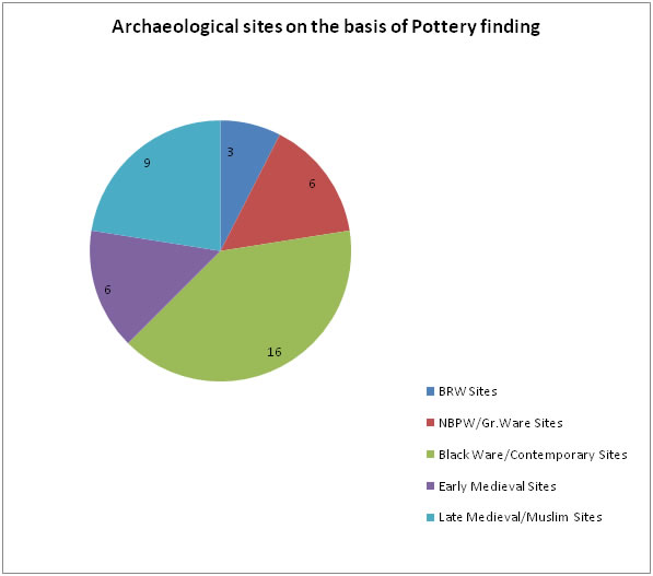
More than three dozen of archaeological
sites were explored in the above mentioned regions. The remains of the
distributaries have been nourishing these sites even today. Distance and
direction wise location of these sites can be seen in the following chart :-
|
Sl.No. |
Name of the site along with distributaries of the Ganges |
Block |
Direction from the district headquarters |
Distance from the district
headquarters |
|
1. |
Amoliasarai , Bhairwar |
Begusarai Sadar |
E |
12 km |
|
2. |
Asurari |
Barauni |
W |
12 km |
|
3. |
Bachhwara dih |
Bachhwara |
W |
32 km |
|
4. |
Bagraha dih |
Barauni |
W |
14 km |
|
5. |
Bari Balia |
Balia |
E |
16 km |
|
6. |
Bihat |
Barauni |
WSW |
17 km |
|
7. |
Bodidih |
Balia |
ENE |
15 km |
|
8. |
Chanan dih |
Birpur |
NW |
12 km |
|
9. |
Cheria dih |
Begusarai Sadar |
NE |
16 km |
|
10. |
Damdama |
Begusarai Sadar |
NE |
16 km |
|
11. |
Farida dih |
Begusarai Sadar |
NE |
11 km |
|
12. |
Hamo dih |
Begusarai Sadar |
WNW |
12 km |
|
13. |
Jogiya dih |
Begusarai Sadar |
N |
09 km |
|
14. |
Kaith |
Begusarai Sadar |
NE |
12 km |
|
15. |
Kankaul |
Begusarai Sadar |
N |
02 km |
|
16. |
Kushmahaut |
Begusarai Sadar |
ENE |
12 Km |
|
17. |
Lodi pur |
Begusarai Sadar |
ESE |
11 Km |
|
18. |
Majhanpur |
Begusarai Sadar |
E |
13 km |
|
19. |
Majhlapur,SokhaBabasthan |
Begusarai Sadar |
ESE |
08 km |
|
20. |
Majhos dih |
Bachhwara |
NW |
30 km |
|
21. |
Maniappa |
Matihani |
SE |
07 km |
|
22. |
Manikpur |
Begusarai Sadar |
NE |
15 km |
|
23. |
Marattha dih |
S.Kamal |
E |
35 km |
|
24. |
Masuriya dih |
Begusarai Sadar |
NE |
10 km |
|
25. |
Matihani |
Matihani |
S |
07 km |
|
26. |
Narsinghpur Sograha |
Barauni |
W |
18 km |
|
27. |
Rajwara |
Barauni |
W |
16 km |
|
28. |
Rampur |
Matihani |
S |
10 km |
|
29. |
Rudauli |
Bachhwara |
NW |
32 km |
|
30. |
Sahuri |
Birpur |
NW |
10 km |
|
31. |
Sanghaul dih |
Begusarai Sadar |
W |
05 km |
|
32. |
Sangokothi |
Begusarai Sadar |
NE |
17 km |
|
33. |
Sankh |
Begusarai Sadar |
NE |
08 km |
|
34. |
Savai dih |
Bachhwara |
WSW |
40 km |
|
35. |
Shahpur |
Begusarai Sadar |
ESE |
10 Km |
|
36. |
Sikandarpur-Rajaura |
Begusarai Sadar |
N |
05 km |
|
37. |
Siraiya dih |
S.Kamal |
E |
33 km |
|
38. |
Suza dih |
Begusarai Sadar |
E |
04 km |
|
39. |
Taraiya |
Begusarai Sadar |
NE |
09 km |
|
40. |
Ulao dih |
Begusarai Sadar |
W |
06 km |
The
present research work has been conducted in a geographical area almost 80 Km
long (East- West) and 20 Km wide (North- South). Extensive survey and
exploration was conducted to find out the expanse of the archaeological sites
along with the distributaries at present live or dead. It brings before us some
clues related to the cultural sequence and its nature in the concerned
geographical area.
First
of all, it is crystal clear that habitation is older in the central part of the
district with respect to the western as well as the eastern part. The
habitation over majority of the mounds in the eastern part seems to come into
existence in or after medieval period. In the central part , there are a number
of N.B.P.W. sites showing the antique nature of the region. Few of them like,
Masuriyadih, Damdama etc represent even earlier period . But this trend is not
similar for the whole central part . The National Highway 31 , which divides
this central part physiographically , also seems putting a division line on the
basis of richness of the sites based on
pottery finding . None of the sites of the southernmost part in the
closer vicinity of the Ganges, represents the antiquity as Masuriyadih or
Damdama does. Majority of the sites in this part of the district seems to come
into existence in the late medieval or Mughal period and are even later than
the sites along with the Balan which has at present occupied the bed of the
Baya. Archaeological sites situated in the eastern part of the concerned area ,
are much older than these sites but again they don’t seem to represent the
oldness and richness of Masuriyadih.
The
research study also indicates that the concentration of the older sites is away
from the Ganges. This supports the notion of making habitats away from big
rivers and preferring the tributaries and distributaries for this purpose.
Smaller rivers would have proved less atrocious and provided the benefit of
connectivity at the same time. So, sites like Savai dih, Bihat, Rampur Matihani
, Maniappa and Sokha Baba Asthan are in the close vicinity of the Ganges. The
following graph shows the number of archaeological sites located at various
distances from the present bed of the Ganges :-
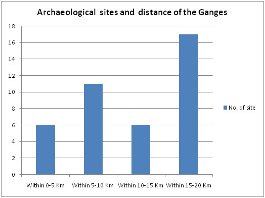 |
The
above chart clearly shows that 34 out of 40 sites are 5km or more away from the
main course of the Ganges. It is remarkable to know that 23 sites are
located10-20 km away from this largest river of India. If we consider the merit
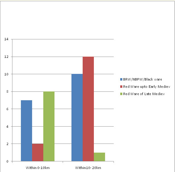
of the explored sites, some interesting facts come before us. 31 sites out of
40 explored yield potsherds representing Early- medieval period or earlier
periods. 22 of them are 10km or more away from the Ganges. Out of 9 sites
representing Late-medieval or Muslim period,8 are closer to the Ganges. The
following graph shows the merit of the explored sites in context with the
distance from the Ganges :-
 |
 |
The
archaeological site of Masuriyadih seems to be in the tradition of Pandgarh, a
site in Samastipur district excavated by Kashi Prasad Jaisawal Research
Institute, Patna .The remarkable finding of BRW in association with the NBP
ware at Masuriyadih suggests that the original inhabitants may be the
Chalcolithic BRW people because BRW potsherds are also in sufficient quantity
here .There is a strong possibility of this site being a Neolithic one in this
region as the BRW potsherds are found in the open section almost 1.5m above the
ground level . Apart from that, we can find almost a dozen of archaeological
sites within a radius of five kilometers from here. Five of them like Jogiya
dih, Damdama ,Majhanpur ,Majhlapur and Chanan are NBPW sites whereas sites like
Cheriyadih ,Kaith ,Manikpur,Sangokothi, Kusmahaut etc are not less important
with their rich landscape.
The
stone sculptures found in this region are indication of the Pala dominance
here. They represent the religious co-existence of the Hinduism and the
Buddhism of the time here also. The tradition doesn’t stop in the late medieval
period. The migration from all around brought with it a synthesizing attitude
to cope up with the differences within the Hinduism. It not only brought the
Vaishnavism and the Shaivism closer, but also provided space for the Shakt cult
to prosper in this region. The sculptures of Harihar from Ulao, the Mukhalinga
at Chakiya ,Chamunda at Pachmba and Baraipura etc are evidence of that
synthesizing sense.
|
|||||||||||||||||||||||||||||||||||||||||||||||||||||||||||||||||||||||||||||||||||||||||||||||||||||||||||||||||||||||||||||||||||
